Polohy
Пологи
Zaporizhia Oblast
Ukraine
[N: 47.46704]
[E: 36.26947]
A pdf version can be downloaded here.
Provided footage content warning: bodies of deceased persons.
https://t.me/geomouse_central/324
https://t.me/geomouse_central/328
Preface
The geopolitical conflict between Ukraine and Russia has resulted in numerous incident sites, often of civilian character, with many of these incidents recorded as they happen or in the aftermath. This handheld footage ends up on various social media channels and other outlets. Some of this footage is collected and hosted on a dedicated Telegram channel linked to a spreadsheet containing information for each incident such as media source, description, and the date posted. A group of volunteers collects, curates, and attempts to pinpoint the geographical coordinates of these incidents. Once the location of an event is found, the spreadsheet is updated accordingly. Organizations like the ‘Centre for Information Resilience’(1) maintain a publicly available online map built upon this geographical data(2). Finding and publishing the geographical location is a critical step in the process of investigative journalism. Moreover, it empowers citizens, journalists, and researchers around the world to stay informed about the events unfolding in the conflict.
Provided footage

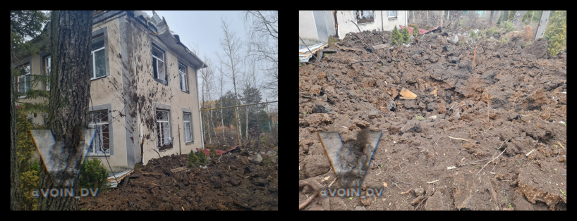
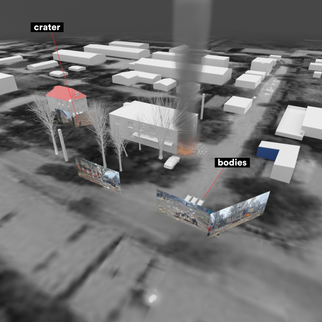
The current case originated from three images and a video shared in a private Telegram channel but forwarded to a public one(3). The scene appears to be of an urban neighborhood with at least two damaged buildings. On a nearby road, three bodies are laid on top of stretchers but were not there at the time the other pictures were taken. According to different media outlets, five people were killed during this incident that happened on January 14th, 2023. Debris is covering the area and is seen hanging on branches of trees. The red rooftop of one of the buildings is a prominent feature visible in both photograph and color satellite imagery when zoomed in on the area. A video of the same street corner and adjacent buildings further supports visual evidence of the aftermath of the incident.
The geographical location of the incident was found via translating the caption of the footage and a quick online satellite map lookup(4):
“орки сьогодні обстріляли Пологи та вбили чотирьох людей. Ще 5 отримали важкі поранення.”
(translation: “Orcs shelled Podoga today and killed four people. Another 5 were seriously injured.”)
“Последствия вчерашнего обстрела города Пологи (Запорожская область)”
(translation: “Consequences of yesterday’s shelling of the city of Pology (Zaporizhia region).”)
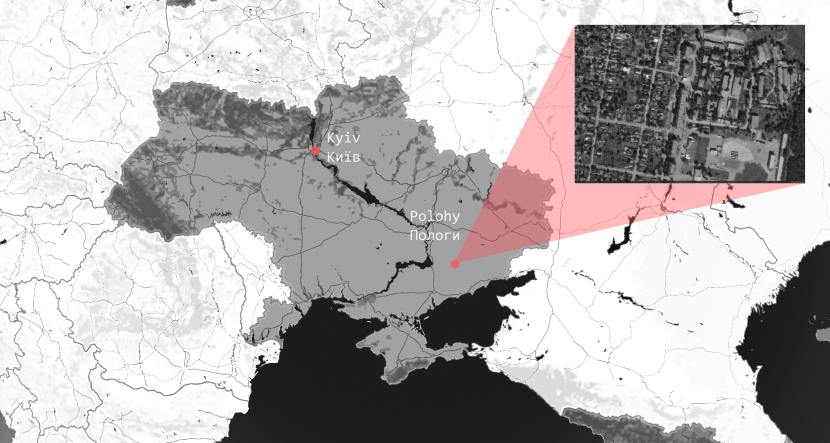
The city of Polohy (Пологи) is situated in the Zaphorizhia region, in the southeastern part of Ukraine. The area can be quickly identified when zooming in on satellite imagery. The location of the road intersection serves as the geographical reference point at latitude:47.46704, longitude:36.26947.
View Larger Map
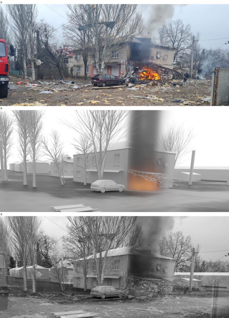
The images in the figure below were found on other channels and media platforms via reverse image search on Yandex, for example. Unfortunately, there wasn’t a very diverse collection of footage available. A few platforms are hosting duplicate images but only one source had more details about the building featuring a red roof, as seen in the background in one of the first images.
It also appears that different media channels are pointing fingers at the opposing country as the perpetrators of the shelling.
Satellite view and location
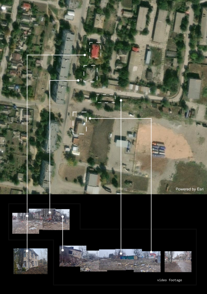
Pinpointing the location of the incident was relatively straightforward. Entering the name of Polohy in almost any satellite imagery platform such as Google Maps or Arcgis’ ‘World Imagery Wayback’ immediately provides clear visuals of the layout of the neighborhood, allowing for accurate identification of the affected area.
The satellite imagery was instrumental in providing a broader context of the incident site, illustrating the neighborhood’s proximity to key infrastructure, roads, and other significant landmarks. Further examination of the images revealed the distinct architectural styles and patterns of the residential area, which were crucial for the subsequent 3D modeling and spatial reconstruction.
Spatial Reconstruction
The building in the footage served as a key reference point in the photogrammetry process, with its identifiable features allowing for the creation of a 3D model of the building and details of the surrounding area. The architectural layout of the area was primarily based on the satellite imagery of Polohy, supplemented by photographs and videos from the incident site. Key identifiable features from both the satellite imagery and ground-level photographs were aligned to position each element within the 3D model.
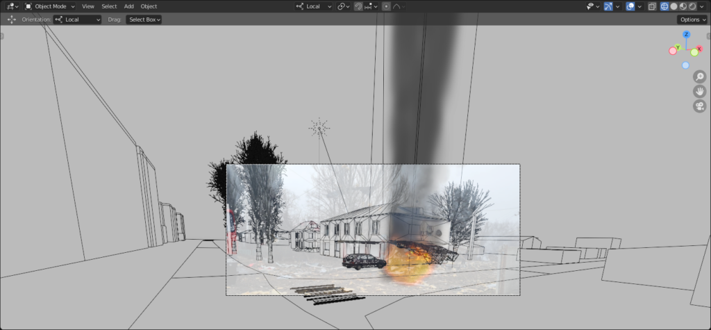
By aligning identifiable features captured in the footage with those in the 3D model, it was possible to pinpoint the location from which the video and images were taken.
By measuring the dimensions of the two corner buildings in the satellite image and knowing the dimensions of the parked car, it was possible to establish a reference scale for the 3D model. Applying this reference, it was estimated that the crater resulting from the incident has a diameter of approximately 9 to 11 meters.

Conclusion
While the main purpose of this report is to highlight the geographical location of the incident in Polohy (in fact, one of several), it is important to remember the human impact of these incidents. Behind each geolocated incident are individuals and communities affected by the conflict. The physical damage depicted in these images is a striking reminder of the human toll and psychological trauma inflicted on the inhabitants of these regions. As we continue to collect, curate, and examine such data, it is our collective responsibility to advocate for peace, justice, and the safeguarding of human rights.
Acknowledgments and Copyrights
- CIR Centre for Information Resilience https://www.info-res.org/faq
- www.Eyesonrussia.org
- Links to Telegram channel footage. Content warning: deceased persons visible. https://t.me/geomouse_central/324, https://t.me/geomouse_central/328
- ESRI World Imagery Wayback https://livingatlas.arcgis.com/wayback
ESRI World Imagery Wayback https://livingatlas.arcgis.com/wayback/
Google Maps https://www.google.com/maps
Google Translate https://translate.google.com/
Mapbox https://www.mapbox.com/
OpenStreetMap https://www.openstreetmap.org
Qgis https://www.qgis.org
Yandex images https://yandex.com/images/Report http://panocular.net