Geolocation is an often inevitable part of a much larger investigation of war crimes, criminal cases, and other unwelcome schemes assembled by humanity. This is my first geolocation case.
Tools and platforms used for this project:
Chrome: Web Browsing and YouTube HTML editing.
Yandex: reverse image search.
ChatGPT: API integration assistance.
Inkscape: creating vector map icons.
Photoshop: image and screenshots cleanup.
OpenStreetMaps: map and coordinates search.
Google, Google Maps, YouTube: many search queries.
Python + Overpass-Turbo API: scripting object search and export.
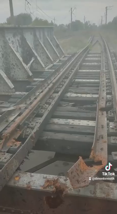
Geolocating Case 540, Railway Bridge.
Location: Kharkiv, Oblast Video
link: https://t.me/now_kharkov/27044
Source: Харьков Сейчас: новости (Kharkiv Now: news)
Comments: Railway bridge (single track)
Steps taken
There’s a single Telegram/TikTok video provided, nothing else. Watching the video point-of-view move around one way to the other, it generally points in only one track direction, however.
The following elements can be observed in the video:
- There’s a single damaged railway track visible, and a uniformed person. Voices can be heard as well.
- There are several poles and powerlines along the track as well as a few buildings/roofs barely visible in the distance.
- The roofs suggest that this location might be positioned near a residential area but at this point is mere speculation.
- There are approximately 8 bridge-supporting elements.
- I also noticed a landmark, parallel to the tracks. Could this be another track perhaps?
- A stream is visible below the bridge.
The description of the video says:
Последствия прилёта ракеты по Ж/Д мосту в Харьковской области (Consequences of the rocket’s arrival on the railway bridge in the Kharkiv region)
It probably makes sense to start looking around the Kharkiv region, but it would be impractical to look for railway passes manually. There are probably many and it is also unclear how large the sheer size of the area would be.
I decided to write a Python script that will search for objects within a certain radius from a chosen center coordinate on OpenStreetMaps. Since I am not up to speed on Python skills yet, and working with map APIs is relatively new to me, I kindly asked ChatGPT to help me with the code. Surely, it provided the requested script after a few iterations and corrections, one example of how AI can serve humans with purpose. The script can be found on my Github
Happy with the script, I set it to work on the area centered around Kharkiv, opting for the [“bridge”][“railway”] search criteria in any layer. The script saves the found longitude/latitude coordinates to a text file.
Within a radius of 5000 meters from the center of Kharkiv, it found 65 locations and within a radius of 10000 meters, it found 93 locations meeting the search criteria. 93 locations are not too much of an inconvenience to go through, since some of these are in the same locations where two tracks temporarily split and many of these points are in line, obviously. However, compared to the sketch, the search did not yield any results.
I felt that there was information missing and I was asking myself if other footage of the area could be found online. So I took a still from the video, facing the bridge along its tracks, and subsequently uploaded this to Tineye and Yandex reverse image search.
Surprisingly, Yandex provided a few interesting results. One result has the same video on TikTok and another result is of a different video on YouTube of what looked like the same location as in the original Telegram video. 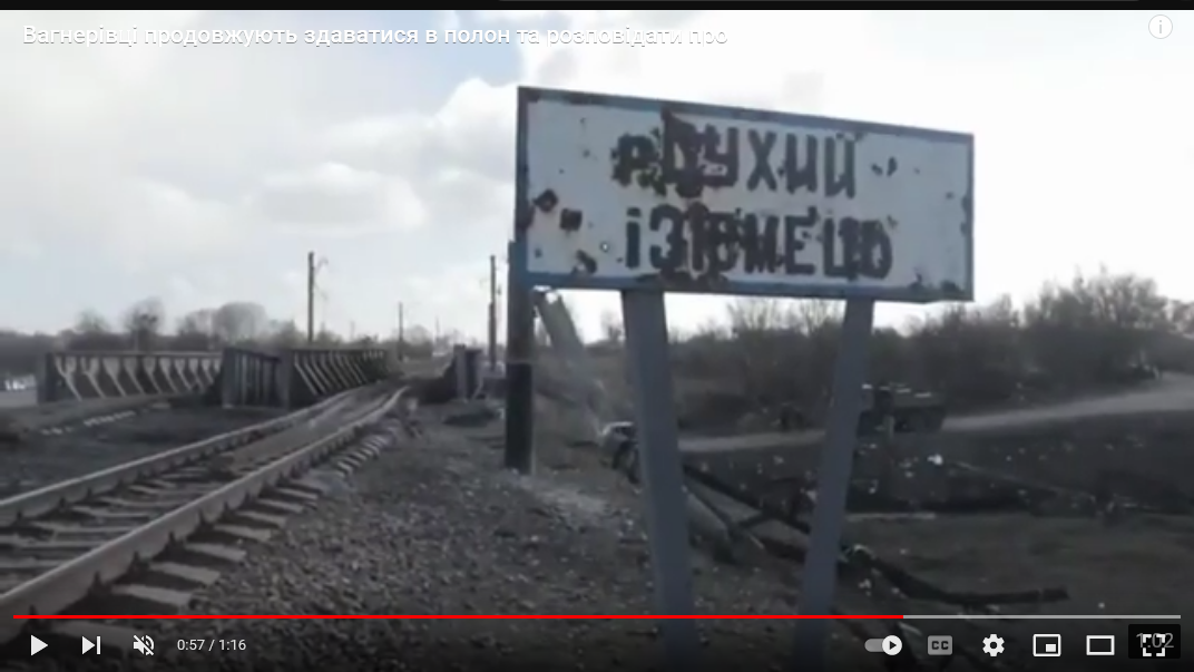
Izyum Fighting continues Ukraine and Russian troops
This new video of apparently the same location as in the Telegram video contains a few new starting points.
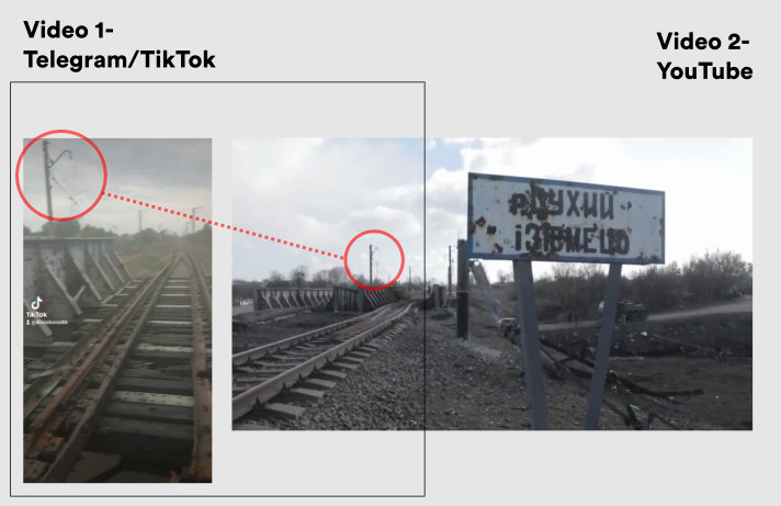
Comparing the damage of the railways in both videos confirms that actually these are of the very same bridge. Note the view direction of both videos faces opposite ways but the damage incurred is of a particular form visible in both videos. Judging by the dirt on the tracks, it follows that both videos were shot at different times. The sign inside the second video provided another clue. However, translation attempts via different online platforms didn’t yield any results (the sign is difficult to read) so I filed a translation request in Bellingcat’s Discord channel and asked a friend.
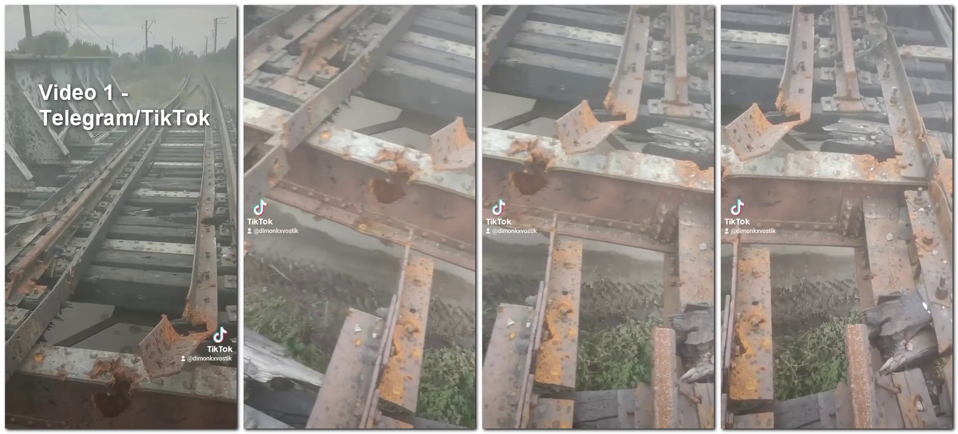
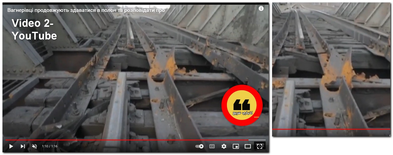
Left: Still from the original Telegram(TikTok). Right: YouTube
Also visible but maybe less convincing, is the damage to poles and power lines in the distance.
The description of the YouTube footage mentions the city of Izyum. This led me to try the Python script once again, around the center of Izyum. The results did not produce a confirmed coordinate however there was one location that needed further investigation. This location seems to match the previously drawn sketch and the infrastructure seen in the footage as well. 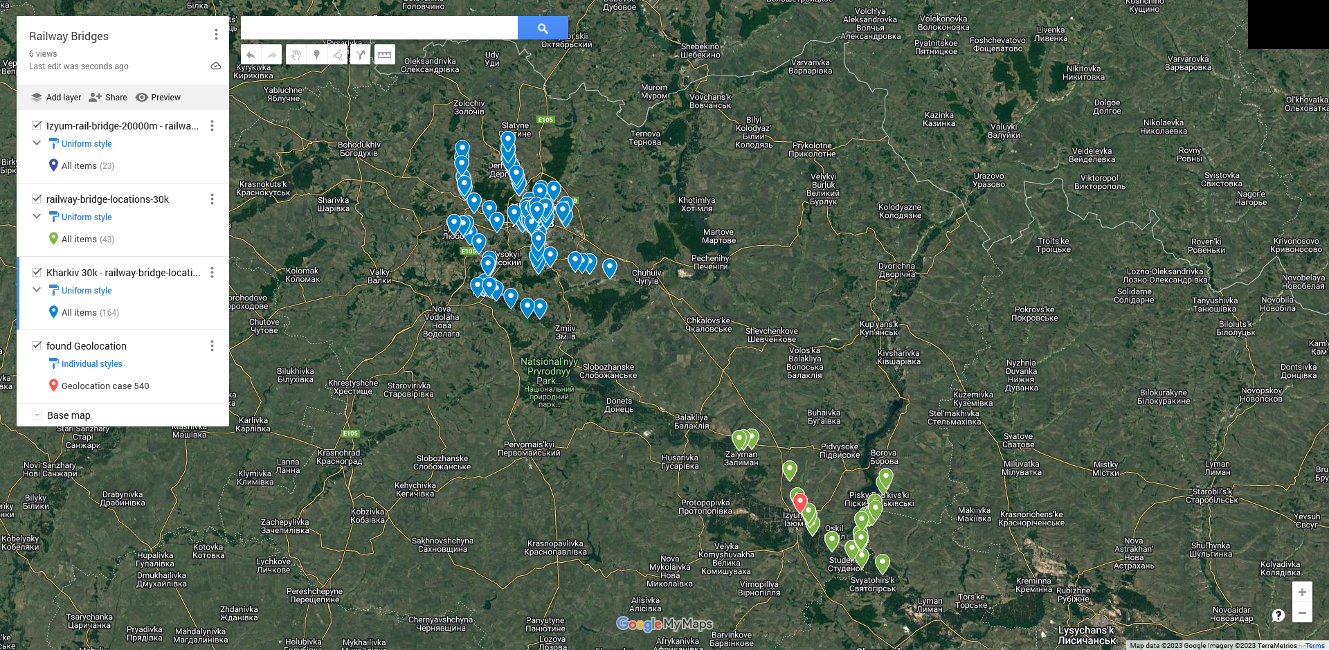
Interestingly, the YouTube video revealed persons and vehicles on a road beside the bridge. It appears as if there is both a road and a watercourse of some sort underneath the bridge. I better doublecheck all previously found locations for both ‘railway bridge’ and ‘road’ and ‘waterway’.
Around the same time, a kind user in the Discord channel answers my translation request.
‘Сухий ізюмецо’ means dry Izyumetso, Google maps mention Sukhyi Izyumets’ River. I quickly check the map for other railway crossings of the Izyumets’ River but the result reveals none, at least nothing remotely similar to the bridge we are investigating.
Conclusion
The combination of the following clues is what led me to believe the found coordinates for this case are actually of the location seen in the Telegram video.
- The particular design of the bridge is seen in both videos.
- The particular damage to the rails is seen in both videos.
- The angle of view toward the buildings seems to correspond with their respective locations on the map.
- The curve and intersection on the road in the YouTube video seem to correspond with the road on the map.
- The damage to poles and power lines is seen in both videos.
- The sign in front of the bridge seems to correspond with the names seen on both OpenStreetView and Google Maps.
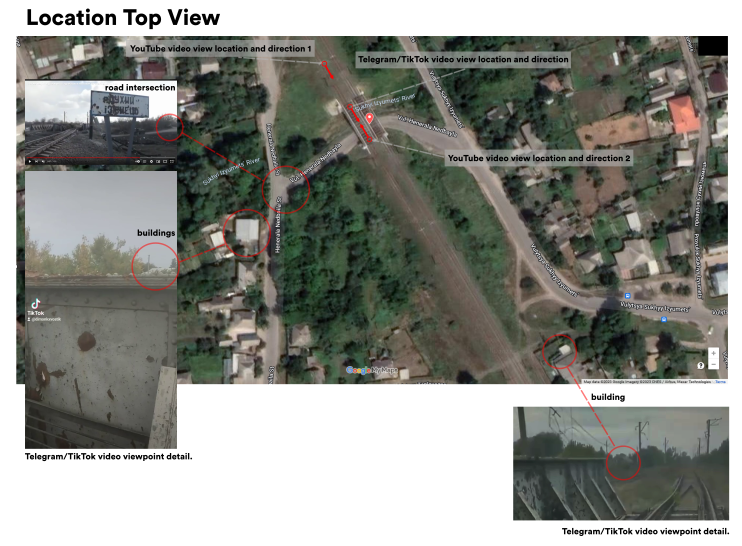
Found Location
All clues combined, the found coordinates near Izyum appear to be the most likely location as seen in the initial Telegram video.
Longitude: 49.2274 Latitude: 37.28754
View Larger Map
Sources:
Original video: https://t.me/now_kharkov/27044
YouTube video: https://youtu.be/bf4I78vQ4Gk?t=55